


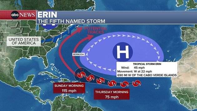
(NEW YORK) — Tropical Storm Erin is forecast to strengthen into the first hurricane of the Atlantic season by Thursday and then become a major Category 3 hurricane over the weekend as it travels north of Puerto Rico.
But as of now, Erin is not expected to pose a direct threat to the U.S.
This weekend, Puerto Rico may get tropical rains from Erin’s outer bands, but impacts will be minimal. Rip currents will pose a major risk for Puerto Rico this weekend and into next week.
The forecast path shows Erin then likely turning north and heading directly to Bermuda or to the west of the island.
Around Aug. 20, once Erin nears Bermuda, it may either hold as a Category 3 storm or gain even more strength as it moves over above-average water temperatures.
Because Erin is one week away, meteorologists in Bermuda and the U.S. East Coast will be watching the storm closely, as any deviation east or west could lead to significant impacts.
While Erin won’t impact the U.S., the storm is forecast to bring dangerous rip currents to the East Coast from about Aug. 21 to Aug. 27.
The National Hurricane Center predicted an above-normal hurricane season for the Atlantic.
August, September and October are the most active months of the Atlantic hurricane season, which ends on Nov. 30.
Copyright © 2025, ABC Audio. All rights reserved.
